Case Study: The Holderness Coast
Coastal erosion in holderness.
The Holderness coast is located next to the city of Hull in the north-east of England. Each year, the Holderness Coast retreats 1-2 metres. The area is particularly vulnerable to erosion because of:


Strong prevailing winds
- Strong prevailing winds create destructive waves that can do more damage to the coast.
- The prevailing winds also mean that any eroded material moves away from the place that was eroded (leaving the soft rock exposed).
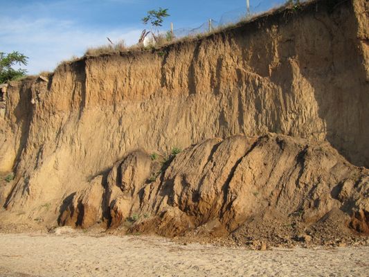
Clay cliffs
- The Holderness Coast is made of boulder clay.
- This is very soft and easy to erode.
- Heavy rainfall can cause mass movements in the boulder clay cliffs.
Coastal Management in Holderness
In 1991, a £2 million project built rock groynes and rock revetments at Mappleton in the Holderness coast. These are examples of hard engineering.
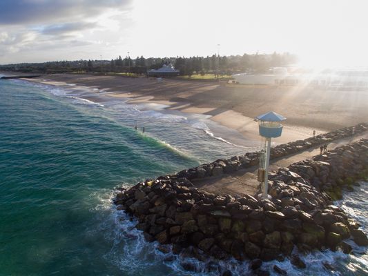
Rock groynes
- The rock groynes tried to stop sediment being carried away from the Holderness Coast and tried to create a larger beach to protect the land behind.
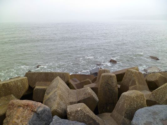
Rock armour
- Rock armour was placed at the foot of the cliffs.
- The rock armour is meant to absorb some of the waves' energy, instead of the coast or cliffs.
What are the Results & Effects of Coastal Management at Mappleton?
The cliffs at Mappleton now erode at 1-2 metres per year, instead of the 7-10 metres before 1991. Mappleton now has a larger beach, however, there have been some negative effects:
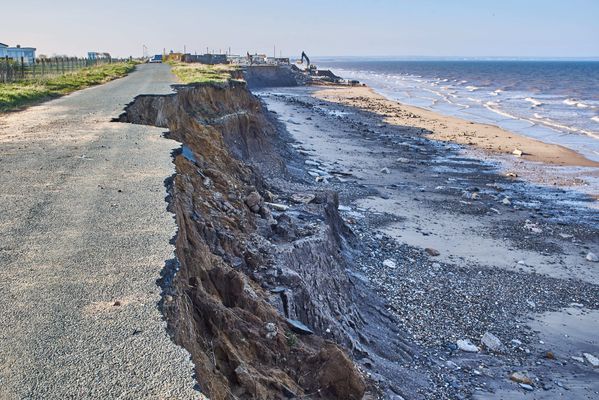
Area south of Mappleton
- The area south of Mappleton is experiencing faster coastal erosion as a byproduct.
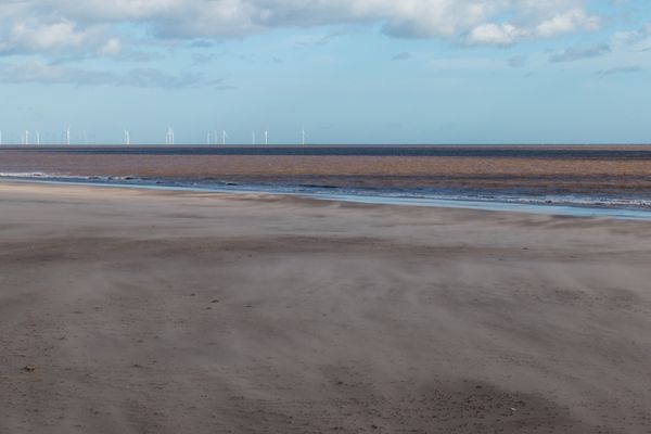
Spurn Point
- The Spurn Point area south, has become less secure.
- Less material is washed down the Holderness Coast.
- Some Hebridean Sheep were washed away and killed. People are now warned not to visit the Point at some times of year, or they too could be washed away.
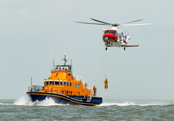
Spurn Point lifeboat & visitor's centre
- £471,000 was spent on a visitor's centre which could become less accessible over time.
- Lifeboat services also operate from Spurn Point.
1 Geography Skills
1.1 Mapping
1.1.1 Map Making
1.1.2 OS Maps
1.1.3 Grid References
1.1.4 Contour Lines
1.1.5 Symbols, Scale and Distance
1.1.6 Directions on Maps
1.1.7 Describing Routes
1.1.8 Map Projections
1.1.9 Aerial & Satellite Images
1.1.10 Using Maps to Make Decisions
1.2 Geographical Information Systems
1.2.1 Geographical Information Systems
1.2.2 How do Geographical Information Systems Work?
1.2.3 Using Geographical Information Systems
1.2.4 End of Topic Test - Geography Skills
2 Geology of the UK
2.1 The UK's Rocks
2.1.1 The UK's Main Rock Types
2.1.2 The UK's Landscape
2.1.3 Using Rocks
2.1.4 Weathering
2.2 Case Study: The Peak District
2.2.1 The Peak District
2.2.2 Limestone Landforms
2.2.3 Quarrying
3 Geography of the World
3.1 Geography of America & Europe
3.1.1 North America
3.1.2 South America
3.1.3 Europe
3.1.4 The European Union
3.1.5 The Continents
3.1.6 The Oceans
3.1.7 Longitude
3.1.8 Latitude
3.1.9 End of Topic Test - Geography of the World
4 Development
4.1 Development
4.1.1 Classifying Development
4.1.3 Evaluation of GDP
4.1.4 The Human Development Index
4.1.5 Population Structure
4.1.6 Developing Countries
4.1.7 Emerging Countries
4.1.8 Developed Countries
4.1.9 Comparing Development
4.2 Uneven Development
4.2.1 Consequences of Uneven Development
4.2.2 Physical Factors Affecting Development
4.2.3 Historic Factors Affecting Development
4.2.4 Human & Social Factors Affecting Development
4.2.5 Breaking Out of the Poverty Cycle
4.3 Case Study: Democratic Republic of Congo
4.3.1 The DRC: An Overview
4.3.2 Political & Social Factors Affecting Development
4.3.3 Environmental Factors Affecting the DRC
4.3.4 The DRC: Aid
4.3.5 The Pros & Cons of Aid in DRC
4.3.6 Top-Down vs Bottom-Up in DRC
4.3.7 The DRC: Comparison with the UK
4.3.8 The DRC: Against Malaria Foundation
4.4 Case Study: Nigeria
4.4.1 The Importance & Development of Nigeria
4.4.2 Nigeria's Relationships with the Rest of the World
4.4.3 Urban Growth in Lagos
4.4.4 Population Growth in Lagos
4.4.5 Factors influencing Nigeria's Growth
4.4.6 Nigeria: Comparison with the UK
5 Weather & Climate
5.1 Weather
5.1.1 Weather & Climate
5.1.2 Components of Weather
5.1.3 Temperature
5.1.4 Sunshine, Humidity & Air Pressure
5.1.5 Cloud Cover
5.1.6 Precipitation
5.1.7 Convectional Precipitation
5.1.8 Frontal Precipitation
5.1.9 Relief or Orographic Precipitation
5.1.10 Wind
5.1.11 Extreme Wind
5.1.12 Recording the Weather
5.1.13 Extreme Weather
5.2 Climate
5.2.1 Climate of the British Isles
5.2.2 Comparing Weather & Climate London
5.2.3 Climate of the Tropical Rainforest
5.2.4 End of Topic Test - Weather & Climate
5.3 Tropical Storms
5.3.1 Formation of Tropical Storms
5.3.2 Features of Tropical Storms
5.3.3 The Structure of Tropical Storms
5.3.4 Tropical Storms Case Study: Katrina Effects
5.3.5 Tropical Storms Case Study: Katrina Responses
6 The World of Work
6.1 Tourism
6.1.1 Landscapes
6.1.2 The Growth of Tourism
6.1.3 Benefits of Tourism
6.1.4 Economic Costs of Tourism
6.1.5 Social, Cultural & Environmental Costs of Tourism
6.1.6 Tourism Case Study: Blackpool
6.1.7 Ecotourism
6.1.8 Tourism Case Study: Kenya
7 Natural Resources
7.1.1 What are Rocks?
7.1.2 Types of Rock
7.1.4 The Rock Cycle - Weathering
7.1.5 The Rock Cycle - Erosion
7.1.6 What is Soil?
7.1.7 Soil Profiles
7.1.8 Water
7.1.9 Global Water Demand
7.2 Fossil Fuels
7.2.1 Introduction to Fossil Fuels
7.2.2 Fossil Fuels
7.2.3 The Global Energy Supply
7.2.5 What is Peak Oil?
7.2.6 End of Topic Test - Natural Resources
8.1 River Processes & Landforms
8.1.1 Overview of Rivers
8.1.2 The Bradshaw Model
8.1.3 Erosion
8.1.4 Sediment Transport
8.1.5 River Deposition
8.1.6 River Profiles: Long Profiles
8.1.7 River Profiles: Cross Profiles
8.1.8 Waterfalls & Gorges
8.1.9 Interlocking Spurs
8.1.10 Meanders
8.1.11 Floodplains
8.1.12 Levees
8.1.13 Case Study: River Tees
8.2 Rivers & Flooding
8.2.1 Flood Risk Factors
8.2.2 Flood Management: Hard Engineering
8.2.3 Flood Management: Soft Engineering
8.2.4 Flooding Case Study: Boscastle
8.2.5 Flooding Case Study: Consequences of Boscastle
8.2.6 Flooding Case Study: Responses to Boscastle
8.2.7 Flooding Case Study: Bangladesh
8.2.8 End of Topic Test - Rivers
8.2.9 Rivers Case Study: The Nile
8.2.10 Rivers Case Study: The Mississippi
9.1 Formation of Coastal Landforms
9.1.1 Weathering
9.1.2 Erosion
9.1.3 Headlands & Bays
9.1.4 Caves, Arches & Stacks
9.1.5 Wave-Cut Platforms & Cliffs
9.1.6 Waves
9.1.7 Longshore Drift
9.1.8 Coastal Deposition
9.1.9 Spits, Bars & Sand Dunes
9.2 Coast Management
9.2.1 Management Strategies for Coastal Erosion
9.2.2 Case Study: The Holderness Coast
9.2.3 Case Study: Lyme Regis
9.2.4 End of Topic Test - Coasts
10 Glaciers
10.1 Overview of Glaciers & How They Work
10.1.1 Distribution of Glaciers
10.1.2 Types of Glaciers
10.1.3 The Last Ice Age
10.1.4 Formation & Movement of Glaciers
10.1.5 Shaping of Landscapes by Glaciers
10.1.6 Glacial Landforms Created by Erosion
10.1.7 Glacial Till & Outwash Plain
10.1.8 Moraines
10.1.9 Drumlins & Erratics
10.1.10 End of Topic Tests - Glaciers
10.1.11 Tourism in Glacial Landscapes
10.1.12 Strategies for Coping with Tourists
10.1.13 Case Study - Lake District: Tourism
10.1.14 Case Study - Lake District: Management
11 Tectonics
11.1 Continental Drift & Plate Tectonics
11.1.1 The Theory of Plate Tectonics
11.1.2 The Structure of the Earth
11.1.3 Tectonic Plates
11.1.4 Plate Margins
11.2 Volcanoes
11.2.1 Volcanoes & Their Products
11.2.2 The Development of Volcanoes
11.2.3 Living Near Volcanoes
11.3 Earthquakes
11.3.1 Overview of Earthquakes
11.3.2 Consequences of Earthquakes
11.3.3 Case Study: Christchurch, New Zealand Earthquake
11.4 Tsunamis
11.4.1 Formation of Tsunamis
11.4.2 Case Study: Japan 2010 Tsunami
11.5 Managing the Risk of Volcanoes & Earthquakes
11.5.1 Coping With Earthquakes & Volcanoes
11.5.2 End of Topic Test - Tectonics
12 Climate Change
12.1 The Causes & Consequences of Climate Change
12.1.1 Evidence for Climate Change
12.1.2 Natural Causes of Climate Change
12.1.3 Human Causes of Climate Change
12.1.4 The Greenhouse Effect
12.1.5 Effects of Climate Change on the Environment
12.1.6 Effects of Climate Change on People
12.1.7 Climate Change Predictions
12.1.8 Uncertainty About Future Climate Change
12.1.9 Mitigating Against Climate Change
12.1.10 Adapting to Climate Change
12.1.11 Case Study: Bangladesh
13 Global Population & Inequality
13.1 Global Populations
13.1.1 World Population
13.1.2 Population Structure
13.1.3 Ageing Populations
13.1.4 Youthful Populations
13.1.5 Population Control
13.1.6 Mexico to USA Migration
13.1.7 End of Topic Test - Development & Population
14 Urbanisation
14.1 Urbanisation
14.1.1 Rural Characterisitcs
14.1.2 Urban Characteristics
14.1.3 Urbanisation Growth
14.1.4 The Land Use Model
14.1.5 Rural-Urban Pull Factors
14.1.6 Rural-Urban Push Factors
14.1.7 The Impacts of Migration
14.1.8 Challenges of Urban Areas in Developed Countries
14.1.9 Challenges of Urban Areas in Developing Countries
14.1.10 Urban Sustainability
14.1.11 Case Study: China's Urbanisation
14.1.12 Major UK Cities
14.1.13 Urbanisation in the UK
14.1.14 End of Topic Test- Urbanisation
14.1.15 End of Topic Test - Urban Issues
15 Ecosystems
15.1 The Major Biomes
15.1.1 Distribution of Major Biomes
15.1.2 What Affects the Distribution of Biomes?
15.1.3 Biome Features: Tropical Forests
15.1.4 Biome Features: Temperate Forests
15.1.5 Biome Features: Tundra
15.1.6 Biome Features: Deserts
15.1.7 Biome Features: Tropical Grasslands
15.1.8 Biome Features: Temperate Grasslands
15.2 Case Study: The Amazon Rainforest
15.2.1 Interdependence of Rainforest Ecosystems
15.2.2 Nutrient Cycling in Tropical Rainforests
15.2.3 Deforestation in the Amazon
15.2.4 Impacts of Deforestation in the Amazon
15.2.5 Protecting the Amazon
15.2.6 Adaptations of Plants to Rainforests
15.2.7 Adaptations of Animals to Rainforests
16 Life in an Emerging Country
16.1 Case Studies
16.1.1 Mumbai: Opportunities
16.1.2 Mumbai: Challenges
17 Analysis of Africa
17.1 Africa
17.1.1 Desert Biomes in Africa
17.1.2 The Semi-Desert Biome
17.1.3 The Savanna Biome
17.1.4 Overview of Tropical Rainforests
17.1.5 Colonisation History
17.1.6 Population Distribution in Africa
17.1.7 Economic Resources in Africa
17.1.8 Urbanisation in Africa
17.1.9 Africa's Location
17.1.10 Physical Geography of Africa
17.1.11 Desertification in Africa
17.1.12 Reducing the Risk of Desertification
17.1.13 Case Study: The Sahara Desert - Opportunities
17.1.14 Case Study: The Sahara Desert - Development
18 Analysis of India
18.1 India - Physical Geography
18.1.1 Geographical Location of India
18.1.2 Physical Geography of India
18.1.3 India's Climate
18.1.4 Natural Disasters in India
18.1.5 Case Study: The Thar Desert
18.1.6 Case Study: The Thar Desert - Challenges
18.2 India - Human Geography
18.2.1 Population Distribution in India
18.2.2 Urabinsation in India
18.2.3 The History of India
18.2.4 Economic Resources in India
19 Analysis of the Middle East
19.1 The Middle East
19.1.1 Physical Geography of the Middle East
19.1.2 Human Geography of the Middle East
19.1.3 Climate Zones in the Middle East
19.1.4 Climate Comparison with the UK
19.1.5 Oil & Natural Gas in the Middle East
19.1.6 Water in the Middle East
19.1.7 Population of the Middle East
19.1.8 Development Case Studies: The UAE
19.1.9 Development Case Studies: Yemen
19.1.10 Supporting Development in Yemen
19.1.11 Connection to the UK
19.1.12 Importance of Oil
19.1.13 Oil & Tourism in the UAE
20 Analysis of Bangladesh
20.1 Bangladesh Physical Geography
20.1.1 Location of Bangladesh
20.1.2 Climate of Bangladesh
20.1.3 Rivers in Bangladesh
20.1.4 Flooding in Bangladesh
20.2 Bangladesh Human Geography
20.2.1 Population Structure in Bangladesh
20.2.2 Urbanisation in Bangladesh
20.2.3 Bangladesh's Economy
20.2.4 Energy & Sustainability in Bangladesh
21 Analysis of Russia
21.1 Russia's Physical Geography
21.1.1 Russia's Climate
21.1.2 Russia's Landscape
21.2 Russia's Human Geography
21.2.1 Population of Russia
21.2.2 Russia's Economy
21.2.3 Energy & Sustainability in Russia
Jump to other topics

Unlock your full potential with GoStudent tutoring
Affordable 1:1 tutoring from the comfort of your home
Tutors are matched to your specific learning needs
30+ school subjects covered
Management Strategies for Coastal Erosion
Case Study: Lyme Regis
- 0 Shopping Cart


Holderness Coast Landforms
AQA GCSE Geography > Physical Landscapes in the UK > Holderness Coast Landforms
The Holderness Coast in East Yorkshire stretches 61 kilometres from Flamborough Head in the North to Spurn Point in the South.
The coastline is one of the fastest eroding in Europe, leading to the formation of a range of coastal landforms characterised by erosion and deposition .
The Geology of the Holderness Coast
Underlying the Holderness Coast is bedrock made up of Cretaceous Chalk. However, in most places, this is covered by glacial till deposited over 18,000 years ago. This soft boulder clay is being rapidly eroded.
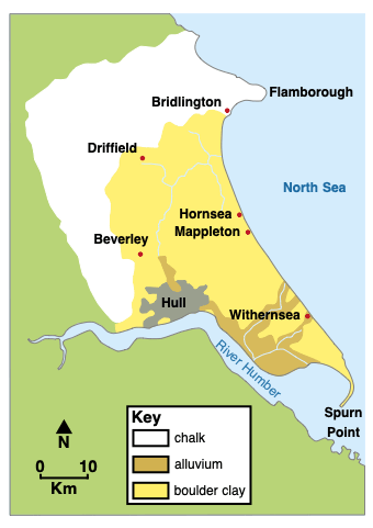
The geology of the Holderness Coast
Landforms of erosion and deposition on the Holderness Coast
Selwicks bay, flamborough.
Flamborough Head is a headland that juts out into the North Sea. It is formed from chalk, a resistant rock.
Several bays are located along Flamborough Head, where the sea has eroded weaknesses in the chalk cliffs. Selwicks Bay is one example. The bay contains a range of coastal landforms of erosion and deposition.
The cliffs here are formed from chalk. Overlying the chalk is a layer of boulder clay.
Erosional processes, including hydraulic action and abrasion , have formed many coastal landforms within Selwicks Bay, including steep cliffs, wave-cut notches, a wave-cut platform, a stack known locally as Stack Adam, and coastal arches.
Landforms of deposition at Flamborough are limited to small beaches formed by the erosion and weathering of cliff material. These beaches consist of chalk from collapsed cliffs and weathering, pebbles from the eroded boulder clay, and sand that has formed from abrasion and attrition .
Landforms of deposition
Beaches have formed along the Holderness Coast due to the deposition of sand and shingle transported by longshore drift . The eroded material is transported from north to south along the coast. Beach material has accumulated at locations such as Hornsea, Withernsea, and Mappleton due to the construction of wood and stone groynes, which trap sediment .
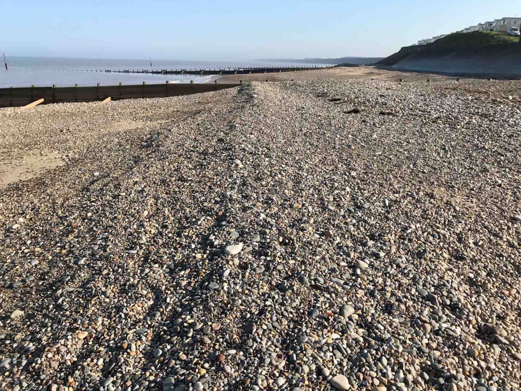
Sand and shingle beach at Hornsea
Spurn Point
In contrast to Flamborough Head, Spurn Point is home to a wide range of coastal landforms of deposition. Spurn Point is a coastal spit formed by the deposition of sediment transported along the Holderness Coast from north to south by longshore drift.
Where the coastline changes direction, material has been deposited to form the sandy spit.
Spurn Point is curved, with a hooked end, because the wind and waves coming from a secondary direction push the tip of the land in that direction, giving it this unique appearance.
Beach material is blown up the beach by the wind, forming sand dunes, which stretch almost the length of Spurn Point and have helped stabilise the spit.
Salt marshes have formed behind Spurn Point, as the River Humber deposits silt and mud in this sheltered estuary area.
The Holderness Coast in East Yorkshire spans 61 kilometres from Flamborough Head to Spurn Point and is known for its rapid erosion.
The region’s geology consists of Cretaceous Chalk covered by glacial till, primarily soft boulder clay, which is eroding quickly.
Flamborough Head, a chalk headland, exhibits various coastal landforms like cliffs, wave-cut notches, a wave-cut platform, a stack, and coastal arches due to erosional processes.
At Flamborough, deposition landforms are limited to small beaches formed from collapsed cliffs and eroded boulder clay.
Spurn Point, in contrast, has a wide range of coastal deposition landforms like a sandy spit, sand dunes, and salt marshes, formed by longshore drift and river deposits.
Spurn Point’s unique curved shape results from the influence of wind and waves coming from a secondary direction.
Share this:
- Click to share on Twitter (Opens in new window)
- Click to share on Facebook (Opens in new window)
- Click to share on Pinterest (Opens in new window)
- Click to email a link to a friend (Opens in new window)
- Click to share on WhatsApp (Opens in new window)
- Click to print (Opens in new window)
Please Support Internet Geography
If you've found the resources on this site useful please consider making a secure donation via PayPal to support the development of the site. The site is self-funded and your support is really appreciated.
Search Internet Geography
Latest Blog Entries
Pin It on Pinterest
- Click to share
- Print Friendly

IMAGES
VIDEO
COMMENTS
Where is the Holderness Coast? What defences are found along the coastline? What is the coastal management at Mappleton? This is the forty-second video for t...
UK Sediment Cell 2. A run through of the dynamic equilibrium that exists and the possibility of feedback mechanisms (positive and negative) kicking in to aff...
Infamous for being the most rapidly retreating coastline in Europe. A look at what can be done to save land and its effects on the rest of the coastline.See...
Mappleton is an excellent case study of an attempt at coastal management, which has a negative impact further along the coast. Spurn Point provides evidence of longshore drift on the Holderness Coast. It is an excellent example of a spit, a depositional landform. Around 3% of the material eroded from the Holderness Coast is deposited here annually.
Case - study - The Holderness Coastline. The Holderness coastline of the East Riding of Yorkshire is widely regarded as one of the fastest eroding coastlines in Europe and has been so since the last ice age. Despite this, it is the home to several towns and many villages and a thriving tourism and fishing industry. ... The Video below shows ...
The Holderness Coastline
The Holderness coastline is composed of chalky bedrock with chalk deposits found between an approximate depth of 20m to 35m below land surface (Pye & Blott, 2015). Coastlines composed of chalk are vulnerable to accelerated erosion because chalk has a weak lithology (Shadrick et al., 2023). In other words, chalk has generally weak physical ...
A GCSE case study of coastal erosion and its management, from http://www.coolgeography.co.uk
The Holderness cliffs. These boulder clay cliffs are formed from material left by ice sheets. They are retreating at an average rate of 1.8 metres per year (ten times the rate in the chalk cliffs). This results from the combined effects of land (cliff-face) processes and sea (cliff-foot) erosion. On land, rainwater enters the clay and the ...
There is a debate about whether or not human beings should attempt to defend coastlines. In the case of the Holderness coastline, its geology (weak clays) waves (destructive during North Sea storms) and Geomorphology (the shape of the coastline allows the waves to break at the base of the cliffs) make erosion almost inevitable.
A level Geography: Coasts case study, The Holderness coast. Introduction. Click the card to flip it 👆. - the coast is 60km long. - The Holderness coastline is in the North of England and runs between spurn head and Flamborough head. - Approximately, 3 miles of land has been lost since Roman times, including 23 towns/ villages.
The Holderness coast is located next to the city of Hull in the north-east of England. Each year, the Holderness Coast retreats 1-2 metres. The area is particularly vulnerable to erosion because of: ... 9.2.2 Case Study: The Holderness Coast. 9.2.3 Case Study: Lyme Regis. 9.2.4 End of Topic Test - Coasts. 10 Glaciers. 10.1 Overview of Glaciers ...
A case study into the Holderness Coast for Edexcel GCSE Geography (9-1).
There was £2.9 million of damage a year before the management was put in place. It produced a sandy beach and alos protects the town, a Grade 2 listed church and the B1242. Strategies: Rock Armour at a cost of £2 million. BUT: South of Mappleton, the rate of erosion has increased significantly. Easington.
Hornsea is a town on the Holderness Coast in the East Riding of Yorkshire. Due to its extensive coastal management, schools across the UK frequently use the town as a case study and fieldwork location. The cliffs at Hornsea consist of boulder clay. Where the cliffs are not protected, the soft geology erodes rapidly to the north and south of the ...
Withernsea Case Study Location. Withernsea is a seaside resort town on the Holderness Coast, situated approximately 10 miles (16 km) north of Spurn Point and 17 miles south of Hornsea where the B1242 meets the A1033.The town is surrounded by rich agricultural land and yet sits close to the cliffs and the North Sea.
About Press Copyright Contact us Creators Advertise Developers Terms Privacy Policy & Safety How YouTube works Test new features NFL Sunday Ticket Press Copyright ...
Holderness coast - CASE STUDY. Get a hint. Holderness key facts x3. Click the card to flip 👆. - coastline is 61km long -> stretches from Flamborough head to spurn head. - most of the cliffs are made of till (boulder clay) - coast is exposed to powerful destructive waves from the north sea during storms. Click the card to flip 👆.
Spurn Point Case Study Location of Spurn. The area known as Spurn forms the southern extremity of the Holderness coast and includes the unique feature of Spurn Point, a sand and shingle spit 5.5km long, reaching across the mouth of the Humber. Geology of Spurn. Spurn is made up of the material which has been transported along the Holderness Coast.
About Press Copyright Contact us Creators Advertise Developers Terms Privacy Policy & Safety How YouTube works Test new features NFL Sunday Ticket Press Copyright ...
The Holderness Coast in East Yorkshire spans 61 kilometres from Flamborough Head to Spurn Point and is known for its rapid erosion. The region's geology consists of Cretaceous Chalk covered by glacial till, primarily soft boulder clay, which is eroding quickly. Flamborough Head, a chalk headland, exhibits various coastal landforms like cliffs ...